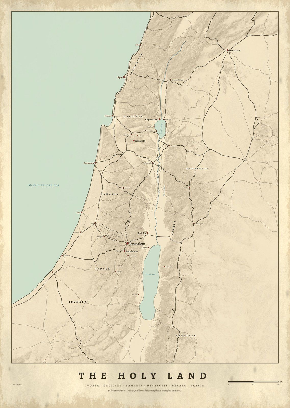
The Holy Land in the Time of Jesus: The Places on the Map
Nazareth to Jerusalem is 103 km (64 miles) in a straight line. The Gospel towns on our Holy Land map, with their ancient names, Pleiades records and distances.
By Thomas van der Bruggen, Cartouche Maps · Published
In a straight line, Nazareth is 103 km (64 miles) from Jerusalem, Bethlehem is 8.3 km (5.2 miles) from Jerusalem, and Capernaum is 33.5 km (20.8 miles) from Nazareth. These are distances between the points on our map of The Holy Land in the Time of Jesus, measured on the curved surface of the earth. They are not walking distances: the roads of the time wound through hills and valleys and were longer.
The map names 34 towns of Judaea, Samaria, Galilee and their neighbors around AD 30. Fifteen of them appear in the Gospels, Magdala only through the name of Mary Magdalene. Here they are, with the ancient names and records of the Pleiades gazetteer, the research database of ancient places that our map uses.
The Gospel places on the map
Each Gospel reference is one example verse, from the World English Bible. The Pleiades title gives the ancient name or names the gazetteer records for the site.
| On the map | Example verse | Pleiades title | Pleiades ID |
|---|---|---|---|
| Bethlehem | Matthew 2:1 | Bethlehem | 687856 |
| Nazareth | Luke 2:39 | Nazareth | 678299 |
| Cana | John 2:1 | Kana? (uncertain) | 678220 |
| Capernaum | Matthew 4:13 | Kefar Nahum/Kapharnaoum | 678231 |
| Bethsaida | John 1:44 | Bethsaida | 678065 |
| Chorazin | Matthew 11:21 | Chorazin | 678091 |
| Magdala | Luke 8:2 | Magdala/Taricheai | 678272 |
| Tiberias | John 6:23 | Tiberias | 678431 |
| Caesarea Philippi | Matthew 16:13 | Paneas/Caesarea Philippi | 678324 |
| Tyre and Sidon | Mark 7:31 | Sidon/Col. Aurelia Pia (Sidon) | 678393 |
| Jericho | Luke 19:1 | Jericho | 687917 |
| Bethany | John 11:18 | Bethania | 156668177 |
| Emmaus | Luke 24:13 | Emmaus/Nicopolis | 687891 |
| Jerusalem | Matthew 2:1 | Ierusalem/Hierosolyma/Col. Aelia Capitolina | 687928 |
A few of these verses in brief: “Jesus was born in Bethlehem of Judea” (Matthew 2:1); Luke says the family “returned into Galilee, to their own city, Nazareth” (Luke 2:39); “there was a wedding in Cana of Galilee” (John 2:1); and “leaving Nazareth, he came and lived in Capernaum, which is by the sea” (Matthew 4:13). Luke 8:2 names “Mary who was called Magdalene”.
How far apart were they?
All distances are straight lines between the points on our map.
| From | To | km | Miles |
|---|---|---|---|
| Nazareth | Jerusalem | 102.6 | 63.8 |
| Nazareth | Bethlehem | 110.6 | 68.7 |
| Capernaum | Jerusalem | 127.8 | 79.4 |
| Bethlehem | Jerusalem | 8.3 | 5.2 |
| Bethany | Jerusalem | 2.4 | 1.5 |
| Jericho | Jerusalem | 22.4 | 13.9 |
| Emmaus | Jerusalem | 24.3 | 15.1 |
| Nazareth | Capernaum | 33.5 | 20.8 |
| Nazareth | Cana | 6.3 | 3.9 |
| Capernaum | Magdala | 9.4 | 5.8 |
| Capernaum | Bethsaida | 4.1 | 2.5 |
| Capernaum | Chorazin | 2.3 | 1.4 |
| Capernaum | Caesarea Philippi | 40.9 | 25.4 |
The pattern is striking. Four Galilee towns of the Gospels, Capernaum, Bethsaida, Chorazin and Magdala, lie within 12.3 km of each other near the Sea of Galilee. Jerusalem is at least 119 km from each of them.
Two places we cannot pin down exactly
Cana. Pleiades has no certain location for Cana. Its only record near Nazareth is “Kana?”, taken from the Barrington Atlas with a question mark, and it sits 8.3 km from the point on our map. Treat the Cana dot as approximate.
Emmaus. Luke says Emmaus was “sixty stadia from Jerusalem” (Luke 24:13). John puts Bethany “about fifteen stadia away” (John 11:18), and on our map Bethany is 2.4 km from Jerusalem. Using John’s ratio, sixty stadia would be about 9.5 km. Our map follows Pleiades in placing Emmaus at Emmaus Nicopolis, 24.3 km from Jerusalem, more than twice as far. That gap is why we flag Emmaus as uncertain.
The rest of the map
The other nineteen places on the sheet are not in this list, but they belong to the same world. They include Caesarea and Joppa on the coast, Masada, Herodium and Machaerus, Qumran, Sepphoris (6.1 km from Nazareth), and Gadara, Gerasa, Philadelphia and Scythopolis. Jerusalem to Caesarea is 86.4 km (53.7 miles) in a straight line, and Jerusalem to Masada 52.3 km (32.5 miles).
See it on the wall
The Holy Land in the Time of Jesus shows Judaea, Samaria and Galilee around AD 30, with the Sea of Galilee, the Jordan, the Roman roads and the towns of the Gospels, and no modern borders.
Place records: Pleiades (CC BY 3.0). Verses: World English Bible (public domain). Distances measured by us between the points on our map, on the WGS84 ellipsoid; straight lines, not routes. Miles converted at 1 mile = 1.609344 km.
On the wall
The Holy Land